


 The total area of the Danube-Prut and Black Sea hydrographic district basin (DPBSHDB) is 14770 km2 within the limits of the Republic of Moldova, which represents 43.6% of the total area of the country. From the administrative-territorial perspective, the DPBSHDB includes 18 administrative districts. From north to south, the district spans about 350 km, with variable width (from 25 km to 120 km). The geographical position and configuration of the district determines a remarkable diversity of geological structure, geomorphological characteristics and climatic conditions. The specificity of these environmental components significantly determines the characteristics of biota, soils, hydrological and hydrochemical characteristics of groundwater and surface water. The average value of the absolute altitude of the district landscape is 142 m, a typical value for the lower regions.
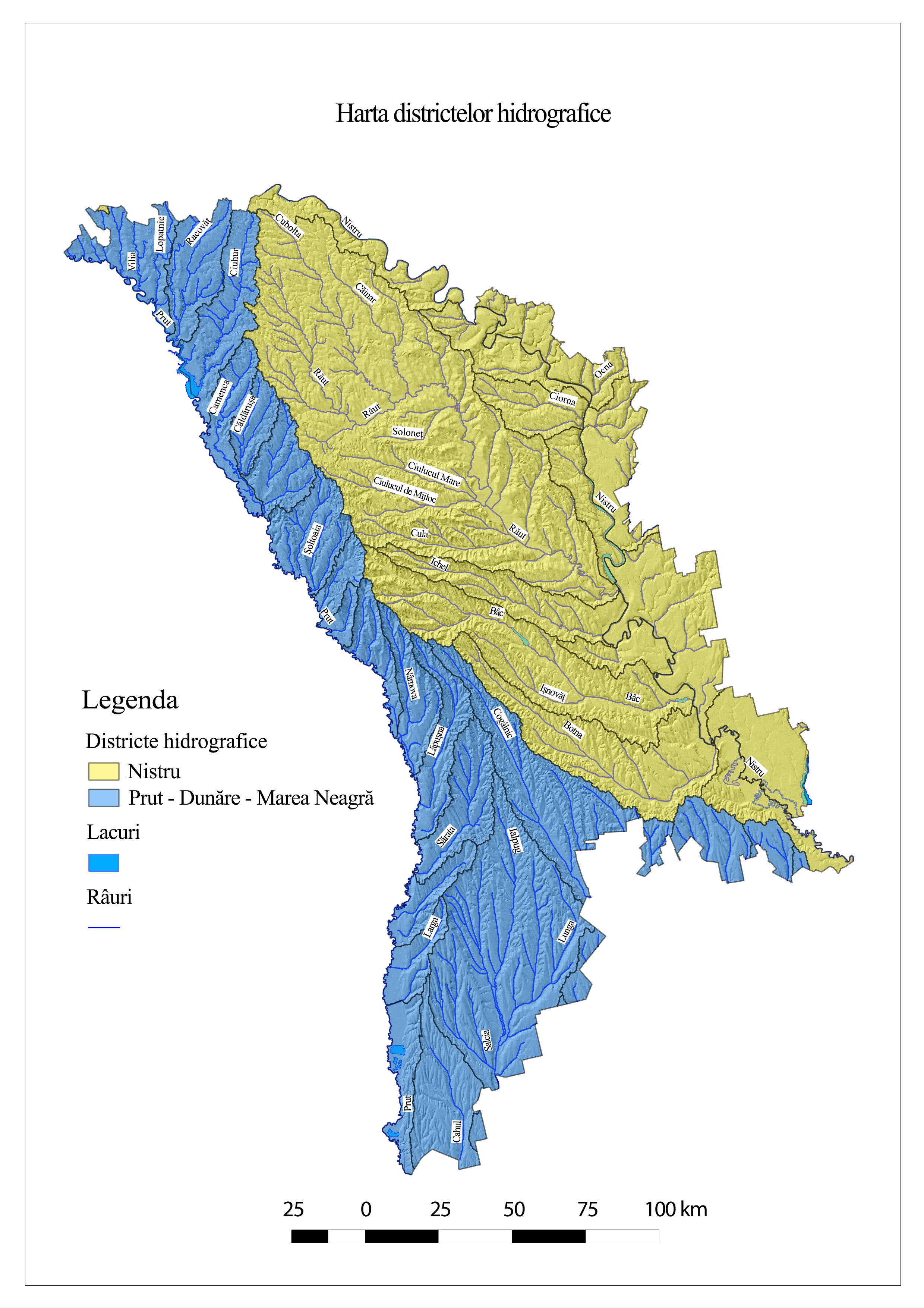
The Prut river basin is part of the Danube basin, representing its eastern border. The Danube Basin crosses the territory of 19 European countries. The Republic of Moldova is a member of the International Commission for the Protection of the Danube and directly manages 0.94% of the total area. The Prut river basin is in the territory of three countries, 28% in the Republic of Moldova (39% in Romania and 33% in Ukraine) out of the total area of 27,540 km2.
Surface water resources - rivers
On the territory of our country, the Prut River has only left tributaries, among which are Racovăț, Larga, Vilia, Lopatnic, Dragiște, Ciuhur, Camenca, Nîrnova, Lăpușna, Sîrma, Sărata, Tigheci, Larga.
Thus, within the Prut river basin, 83 surface water bodies were delimited, with a total length of 2152 km. The average length of the water-river bodies is 26 km and only one water body has a length exceeding 100 km, the average area of the water-river bodies basins is 99 km2, 55 have an area of less than 100 km2. The average annual volume of drainage of the Prut River is equal to 2.7 km3 and ranges from 1.2 km3 in years with insufficient humidity to 5 km3, values obtained in years with high water resources. The average annual flow is 78 - 94 m3 / s, the fluctuations vary between 40 and 162 m3 / s.
The surface water resources in the Danube - Black Sea basin is quite modest. The region accounts for only about 1% of the country's total surface water resources.
Surface water resources - lakes
In the Danube - Black Sea basin, natural lakes are practically absent. Only a small sector on the north side of Lake Cahul, administratively belongs to the Republic of Moldova, most of the surface of this sector being occupied by hydrophilic vegetation. The largest lake in the Prut valley is Beleu Lake, which is in the lower Prut River between the villages of Văleni and Slobozia Mare.
The natural dam lakes were formed as a result of the landslide processes. Their surface does not exceed a few hectares, and the depth reaches 1,0-1,5 m. These lakes are in the landscape reserve "Suta de Movile."
About 1350 accumulation lakes are in the Prut river basin, with a total area of 75.3 km2. They can be grouped, conventionally, into two categories: ponds (with a volume of up to 1 million m3) and accumulation lakes (with a volume of over 1 million m3).
In the Danube - Black Sea basin, 1452 anthropic lakes were identified, of which 5 accumulation lakes with an area greater than 1 km2 (Taraclia, Congaz, Comrat, Caplani, Ucrainca), 11 lakes with a surface of 0.5-0.99 km2 , 11 lakes with an area of 0.25-0.49 km2 and 1425 lakes with an area under 0.25 km2. The water of many lakes is characterized by a degree of mineralization that can exceed 2.0 -5 g / l.
Within the limits of the Prut river basin are 46 accumulation lakes, with a total (projected) volume of approximately 825.52 million m3. Costești-Stânca is the largest accumulation lake on the Prut River. Estimates show that, during the operation of the accumulation lakes, as a result of the clogging processes, their volume decreased on average by 0.50% per year, and the volume of Lake Costesti-Stânca - by 0.58% per year, so in 2015, its actual volume constituted about 577.3 million m3.
Groundwater resources
Within the Prut river basin, groundwater resources constitute 137.38 million m3 / year, of which 50.61 million m3 / year are used for various purposes: as domestic and drinking water - 39.84 million m3 / year (78.32%), as technical water - 10.16 million m3 / year (20.09%), and for therapeutic and recreational purposes - 0.71 million m3 / year (1.58%).
The total reserves of groundwater exploitation of the Danube - Black Sea Basin are estimated at 105.6 thousand m3 / day, of which domestic-drinking water 104.46 thousand m3 / day and industrial-technical waters, 8.5 thousand m3 / day.
Within the Prut river basin within the limits of the Republic of Moldova, in some cities, groundwater represents the main source of drinking water supply (in Edinet district - 100% of the supplied drinking water comes from underground water wells, in Briceni district - 96.49% , in the district Cahul 93%).
Hydropower
Within the Danube-Prut and Black Sea hydrographic district, there is a single Hydroelectric Power Plant (HPP) located on Prut river, near Costești city, 576 km away from the river source. It was built on the Prut River in collaboration with Romania in 1978 and put into operation in 1979. The power is exploited by 2 plants with an aggregate of 16 MW (for each part - Moldovan and Romanian) at a flow rate of 2 x 65 m⊃3; / sec, with an average annual power of 2 x 65 GWh. Electricity production is equally distributed between Moldova and Romania.
HPP Costești-Stânca was built to regulate the flow of vitreous and produces electricity, as well as to provide irrigated agriculture, the processing industry, etc. with water resources.
Places of interest
Along the Prut River there is an important wetland (Ramsar site) which was also declared Biosphere Reserve: "Lower Prut". There is also the scientific reserve "Pădurea Domneacsă", 3 Monuments of the Geological and Paleontological Nature, 5 Forest Natural Reservations, 5 Landscape Reservations and 2 Mixed Natural Reservations. The lower region of the Prut lakes is included in the list of wetlands of international importance, as the Ramsar area no. 1029 "Lakes of Lower Prut" (especially as a habitat for aquatic birds).
Importance
The Prut River passes through several important cities in the Republic of Moldova (Glodeni, Ungheni, Cahul), supplying these localities with drinking water. Near the Costești locality, a hydropower facility (dam, storage lake and hydro-energy node) operates, which supplies electricity to important regions of Romania and the Republic of Moldova. The largest water reserves in the Prut River are registered in the most populated and respectively industrialized districts - Edinet (sugar factories), Ungheni and Cahul (beverage productions).
Problems
The water of the Prut River is polluted as a result of the discharge of the domestic waste and wastewater from the sewage systems of the cities on the bank of this river. The pollution is also accentuated by the technical waters discharged from the economic agents and the representatives of the local industries.
In the Danube - Black Sea river basin over 80% of the captured water comes from underground sources. Due to the increased mineralization, the captured groundwater has a practically exclusive use for domestic purposes and requires a pre-treatment.
In conclusion, almost all river water bodies in the Danube-Prut river basin and the Black Sea are at risk of failing to meet the environmental objectives (table 1). This can be explained by the fact that almost all water bodies are subject to specific types of pressure: pollution, diffuse pollution through agriculture, point pollution caused by wastewater discharge, hydrological modification, due to possible (illegal) abstraction of water, hydro morphological modification as a result of the embankment and drainage adjustment effect.
Table 1. Water quality of water bodies in the river basin of the Prut river.
|
Monitoring point |
Water status according to biological parameters |
Water status according to chemical parameters |
Water status according to hydromorphological parameters |
Ecological status Statut ecologic |
|
r.Prut – v..Criva |
|
III |
|
III |
|
r.Prut – v.Lipcani, 0,2 km upstream |
III |
III |
I |
III |
|
r.Prut – v.Branişte, 0,2 km upstream |
III |
III |
|
III |
|
r.Prut – c.Ungheni, 1,2 km downstream of bridge |
II |
III |
I |
III |
|
r.Prut – v.Valea Mare, downstream of r.Jijia mouth |
III |
IV |
II |
IV |
|
r.Prut – c.Leova, 0,2 km upstream |
II |
IV |
I |
IV |
|
r.Prut – c.Cahul, 3,5 km downstream |
III |
IV |
|
IV |
|
r.Prut - v.Giurgiuleşti |
III |
V |
II |
V |
|
r. Șovățul Mare - v. Ilenuța |
III |
V |
|
V |
|
r. Camenca - v. Camenca |
III |
V |
IV |
V |
|
r. Ciuhureț – v/ Zaicani |
III |
IV |
|
IV |
|
r.Ciuhur – v.Horodişte |
III |
IV |
IV |
IV |
|
r. Delia - c. Ungheni |
III |
V |
|
V |
|
r. Delia - v. Pîrlița |
IV |
V |
|
V |
|
r. Frăsinești - v. Frăsinești |
III |
V |
|
V |
|
r. Larga - v. Chircani |
III |
V |
IV |
V |
|
r. Nîrnova - v. Ivanovca |
II |
V |
III |
V |
|
r. Racovăț - v. Gordinești, amonte |
III |
IV |
IV |
IV |
|
r. Sărata - v. Vozneseni |
III |
V |
III |
V |
|
r.Sărata – v.Vîlcele, în aval |
IV |
V |
I |
V |
|
r. Tigheci - v. Tigheci |
III |
V |
IV |
V |
|
r. Valea Calmage - v. Zîrnești |
III |
V |
IV |
V |
|
r. Varșava - v. Valea Mare |
III |
V |
|
V |
|
r. Vilia - v. Tețcani |
III |
IV |
II |
IV |
|
r.Gîrla Mare - v.Catranîc |
III |
V |
III |
V |
|
r.Gîrla Mare - v. Sărata Nouă |
III |
V |
|
V |
|
r.Lăpușna - v. Lăpușna |
III |
V |
IV |
V |
|
r.Lăpuşna – v.Sărata Rezeşi |
V |
V |
II |
V |
|
baz.Costeşti - on r.Prut, c.Costeşti |
II |
III |
|
III |
|
lake Manta – v.Manta |
III |
IV |
|
IV |
|
Lake Beleu – v.Slobozia Mare |
III |
IV |
|
IV |