


The Dniester Basin Committee The Dniester Basin Committee
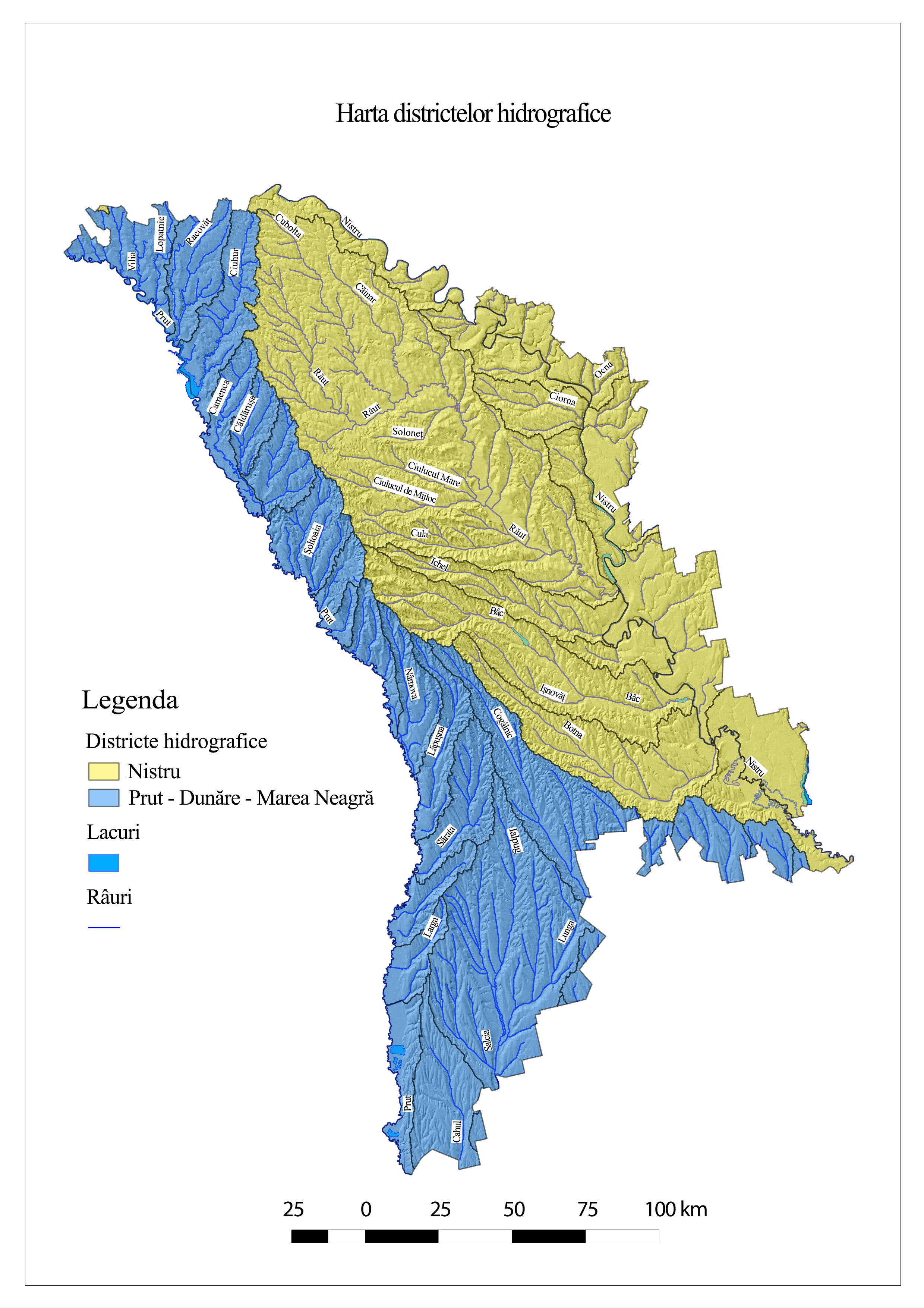 The Dniester River Basin District (hereinafter - the Dniester District) is part of the Black Sea River Basin. Only a small part of the basin of a left tributary is in the territory of Poland. In the west, the Dniester river basin is adjacent to the Prut basin, to the northwest - to the Vistula basin, to the north - to the Dnieper basin, to the east - to the South Bug basin, to the south-east and southwest - to the small river basins that flow into the Black Sea. The Dniester River, that springs in the Carpathian Mountains at an altitude of 911 m, has a total length of 1350 km and is the most important aquatic artery of the country, on whose territory the length of the watercourse (Naslavcea – Palanca) is 636 km. For 142.5 km, the river constitutes the border between the Republic of Moldova and Ukraine.
With a total area of over 72.1 thousand square kilometres, the Dniester basin, within the limits of the country, has an area of 19.2 thousand square km, or 26.5% of the total territory of the basin. Being distributed asymmetrically with the main axis of the Dniester valley, the left region of the basin (within the limits of the Republic of Moldova) is 3.5 thousand square km (18.27%), and the right one - 15.7 thousand square km (81.72%). The water resources of the Dniester basin within the territory of the Republic of Moldova are estimated at 10 700 million cubic meters, of this volume, less than 30% are formed on the territory of the country. The volume of water resources currently available in the country is estimated at about 500 cubic meters/capita/year, which places the Republic of Moldova in the category of countries with insufficient water and with an increased risk to the impact of climate change. The Dniester River is the main source of water in the region, because the reserves of groundwater are insignificant.
All water bodies in the Republic of Moldova are part of two hydrographic districts: (i) the Danube-Prut and the Black Sea and (ii) the Dniester. Within the Dniester District, there are 14 delimited hydrographic basins. From the administrative point of view, the Dniester District includes 39 cities and 554 villages, comprising all or part of the territory of 19 districts.
According to the classification of surface waters, the water of the Dniester river belongs to quality classes II and III. At the same time, practically all the tributaries have the quality class V, which denotes that the tributaries of the Dniester river on the right side, within the limits of the Republic of Moldova, are highly polluted and their water can be used directly only for the purposes of generating electricity and transport, for the other purposes water requires prior treatment.
Table 1. Relationship between water use/function and water quality classes.
| Use/function |
Differenсe of use/ |
Water quality class | ||||
| I | II | III | IV | V | ||
| Ecosystems functioning | + | + | - | - | - | |
| Fish farming/fish protection | Salmonide | + | + | - | - | - |
| Ciprinide | + | + | + | - | - | |
|
Water supply for human consumption, including branches |
Simple treatment | + | + | - | - | - |
| Normal treatment | - | - | + | - | - | |
| Advanced treatment | - | - | - | + | - | |
| Bathing/recreation | + | + | + | - | - | |
| Irrigation | + | + | + | - | - | |
| Industrial purposes (technological processes, cooling) | + | + | + | + | - | |
| Hydroenergetics | + | + | + | + | + | |
| Transport | + | + | + | + | + | |
Note: + use/function accepted from the water quality point of view; - use/function unaccepted from the water quality point of view, the use is forbidden.
Source: Planul de gestionare al districtului bazinului hidrografic Nistru, aprobat prin Hotărîrea de Guvern nr. 814 din 17 octombrie 2017.
Text developed and adapte by Elena Culighin